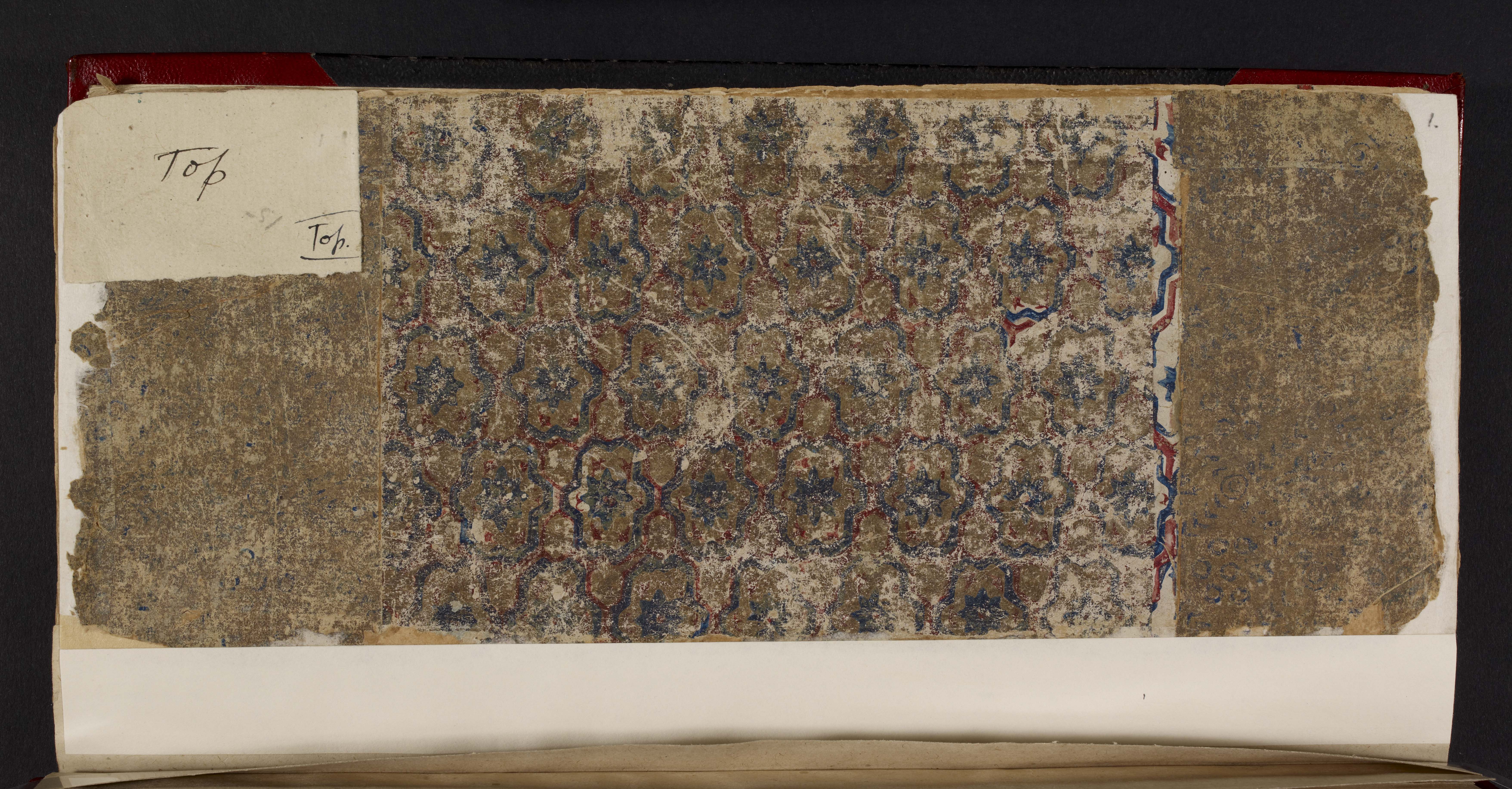
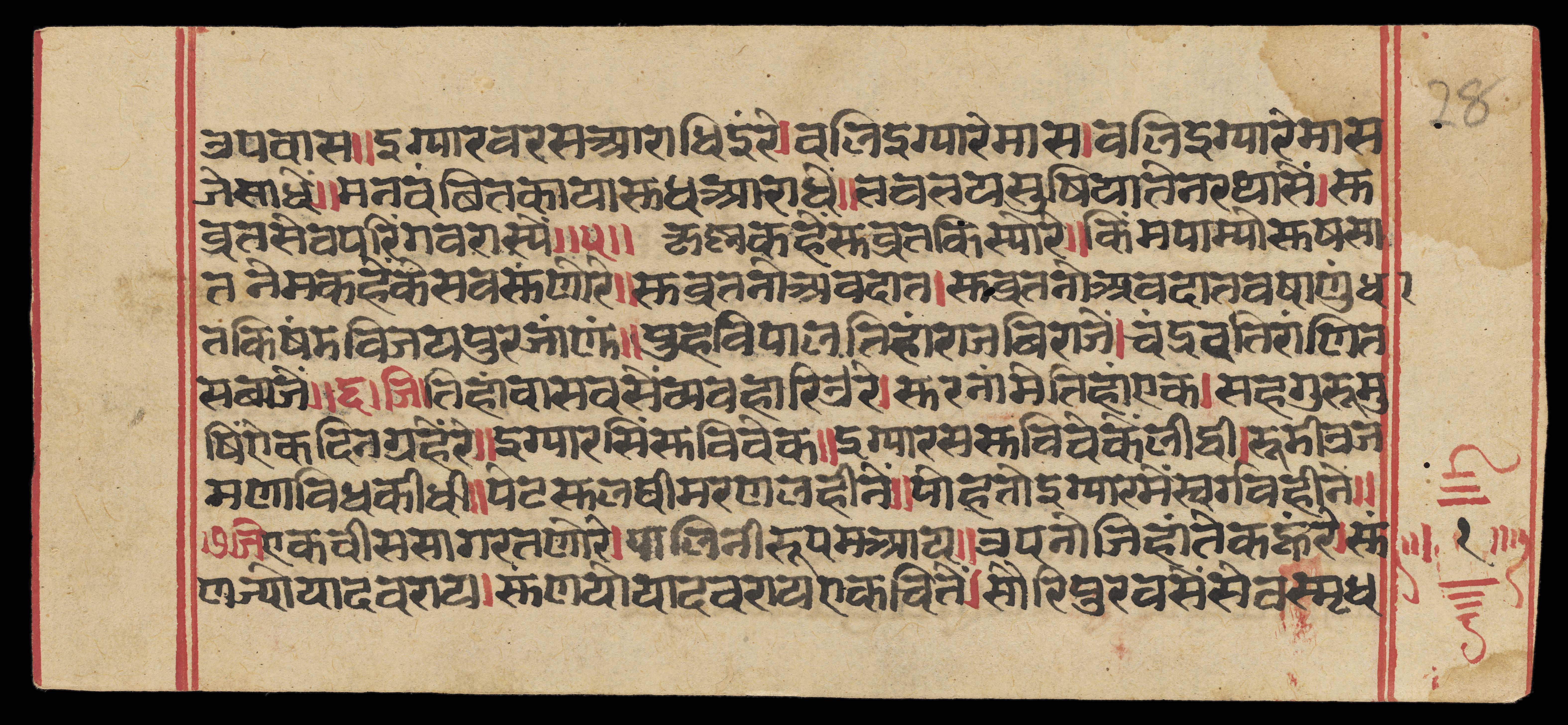
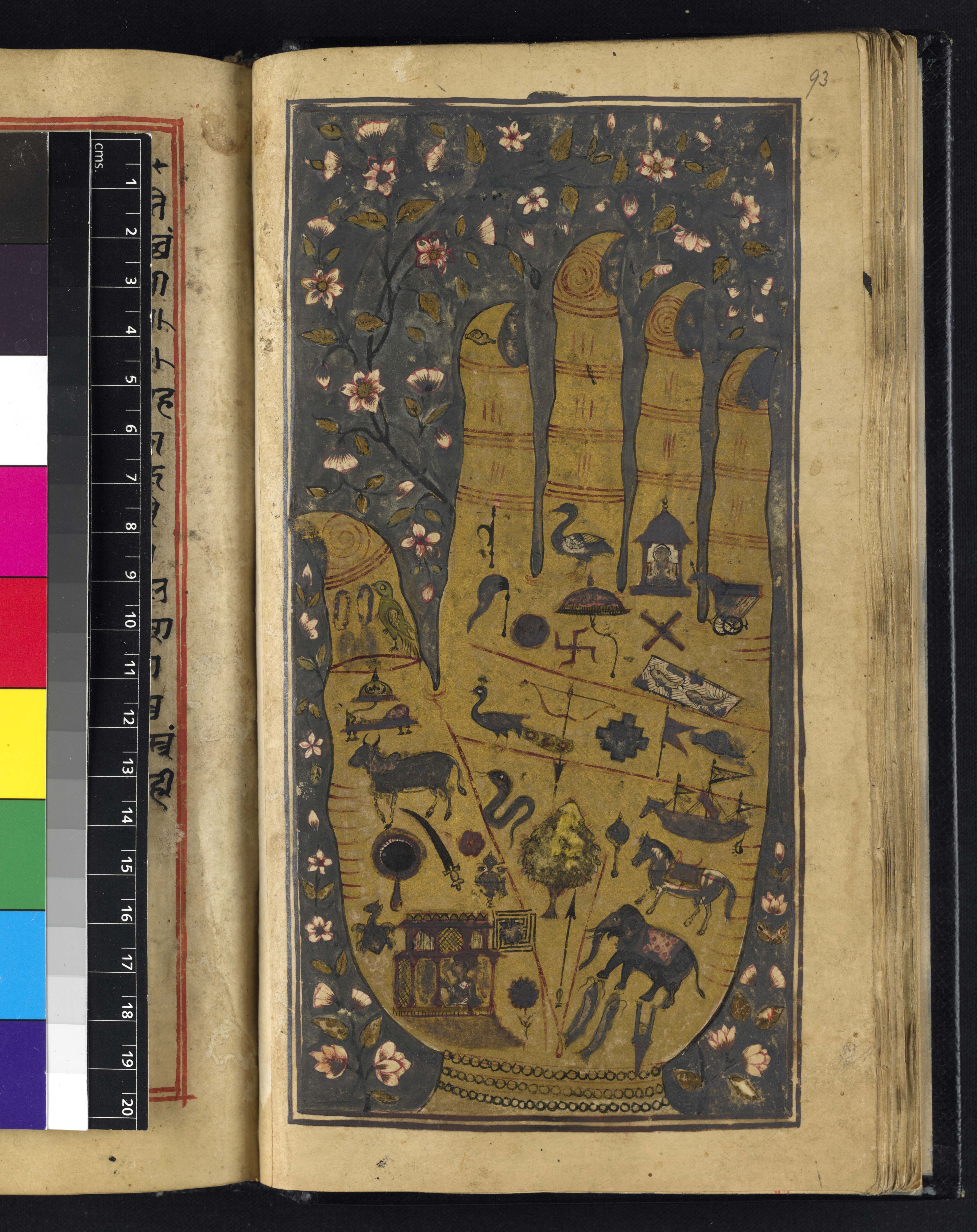


Background
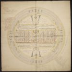
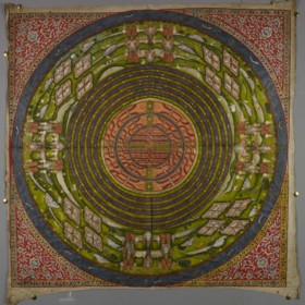
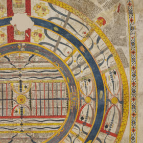
Aḍhāī-dvīpa is the Hindi phrase for ‘Two and A Half Continents’ and describes the only part of the universe where human beings live in the Middle World of Jain cosmology. Frequently depicted in maps or colourful diagrams, it is the only part of the universe where people can be born so it is also known as ‘the World of Humans’ – manuṣya-loka.
The Two and A Half Continents is formed of concentric rings of differing size. Every other ring is a continent, which is surrounded by a ring of ocean. Moving from the centre outwards, the order is as follows:
- the central continent, called Jambū-dvīpa
- the first ocean, known as Lavaṇa-samudra or ‘Salt-Ocean’
- the second continent, Dhātakīkhaṇḍa
- the second ocean, called Kālodadhi or ‘Black-water Ocean’
- half of the third continent known as Puṣkara-dvīpa.
Mount Meru is the centre of the universe in Jain cosmology, at the heart of the central continent of Jambū-dvīpa. Jambū is where human beings live and is in the Middle World, one of the three worlds of traditional Jain cosmology.
The Middle World is the smallest of the three worlds that make up world space – loka-ākāśa. In world space all the souls live in the different body-forms they take according to their rebirths, in the various worlds. Outside world space is the non world space – aloka-ākāśa – which is endless. However, the Middle World is the most important area from the spiritual point of view because it is the only part where human beings can live.
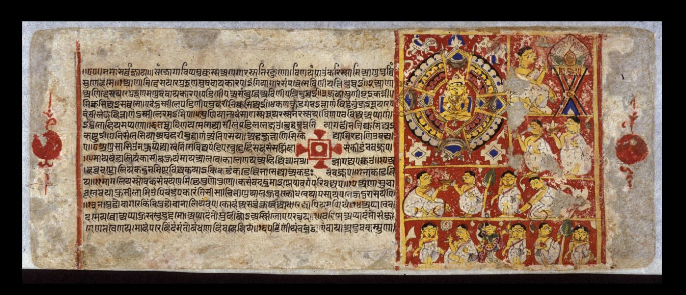
Pictures in cosmological works are not intended to be merely attractive. Spelling out in visual form the complex explanations found in the writings, cosmological paintings form a long-established tradition of artwork in Jain heritage.
Jains cannot advance spiritually without understanding and meditating upon cosmological theories so understanding them is crucial. Certain key religious concepts run through these theories. These include the notion of a physical soul shedding karma by moving through the cycle of rebirth to eventual omniscience and final liberation, along with the cyclical nature of time, the interconnectedness of the universe, and the importance of symmetry, repetition and balance.
Glossary
Description
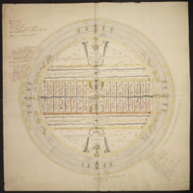
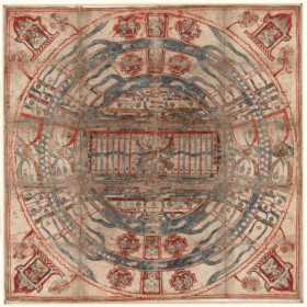
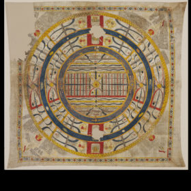
Mount Meru
The three concentric circles in Mount Meru represent its three terraces. On the top is the pinnacle with the customary temple to the Jinas. On each side of each Mount Meru are two semicircles, one yellow, one red and grey. They are the boundaries of two regions. The northern one is called Uttara-kuru, the southern one Deva-kuru. Each region has a specific tree.| Colour in this painting | Location | Region | Name of the tree |
|---|---|---|---|
| Yellow | North | Uttara-kuru | Jambū tree |
| Red and grey | South | Deva-kuru | Śālmalī tree |
Jambū-dvīpa
Across the centre of Jambū is a large rectangular strip marked out by a green line in the north and a red one in the south. These are ranges of mountains, which are easily recognisable in most paintings because of their standard colours. The Nīla mountain range is in the north and is marked in green while the Niṣadha mountain range in the south is outlined in red. They mark the boundaries of the Mahā-videha, which has Mount Meru at its centre. The Mahā-videha is a land of wonders, where Universal Monarchs go and where Jinas preach. The Mahā-videha is divided into 32 provinces, distributed as eight groups of four, equally in the north-east, south-east, north-west and south-west. They are always shown as small rectangles, like here. On this painting the names of these provinces and their capitals are given. The green trees on the borders of the Mahā-videha stand for the forests in this region.Lavaṇa-samudra
The first ocean, starting from the centre, is the thick blue-grey ring around Jambū. Called Lavaṇa-samudra, it has one pot in each of the four directions. These are the 'great receptacles' – pātāla-kalaśas – that cause the tides. Fish and other aquatic animals live here, often depicted as realistic or semi-fantastic creatures. There are two horizontal yellow lines ending with double hook shapes shown in the north and south of this ocean. These are two mountain chains that end with double pairs of 'tusks' jutting out into Lavaṇa-samudra. These tusks carry the 56 islands known as Antara-dvīpas. The islands are divided into seven groups of eight, shown here as dots.Dhātakīkhaṇḍa
From north to south there are parallel red vertical lines dividing the Dhātakīkhaṇḍa and Puṣkara-dvīpa continents into two halves, eastern and western. Each half has temples dedicated to the Jinas. The four segments of these parallel lines on land represent a mountain range known as Iṣvākāra or 'Arrow-like' because it is perfectly straight. On the right and left sides of the red vertical lines, the yellow lozenges are capital cities with palaces. The royal couples who live in them are shown on the map in yellow structures representing the palaces. There are two yellow discs on the left and right and two semicircles on each side of these discs. These are replicas of Mount Meru and the two Lands of Enjoyment, Uttara-kuru and Deva-kuru. The numerous snake-like dark blue shapes are rivers flowing in the continents. The small black rectangles in many places are the lakes where these rivers rise.Kālodadhi
This ocean is the blue ring separating the continents of Dhātakīkhaṇḍa and Puṣkara-dvīpa. It often contains fantastic creatures.Half Puṣkara-dvīpa
The Puṣkara continent is a replica of Dhātakīkhaṇḍa. However, the outer border of Puṣkara-dvīpa is shown by a slim yellow ring. This is the outer mountain range called Mānuṣottara. Even though half of the continent lies on the far side, no human beings can live outside this mountain range.Other visual elements
The painting has captions identifying the elements of the world and also paragraphs giving details of dimensions and so on. As is usual, a Jain temple has been set at each of the four corners of the painting. One is missing because the artefact is damaged. There is an image of a Jina in the centre, which is meant to be worshipped. This is a standard representation to suggest that Jain teaching is everywhere. The floral border around the edge of the painting is a fine ornamentation.Text
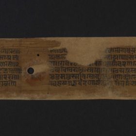
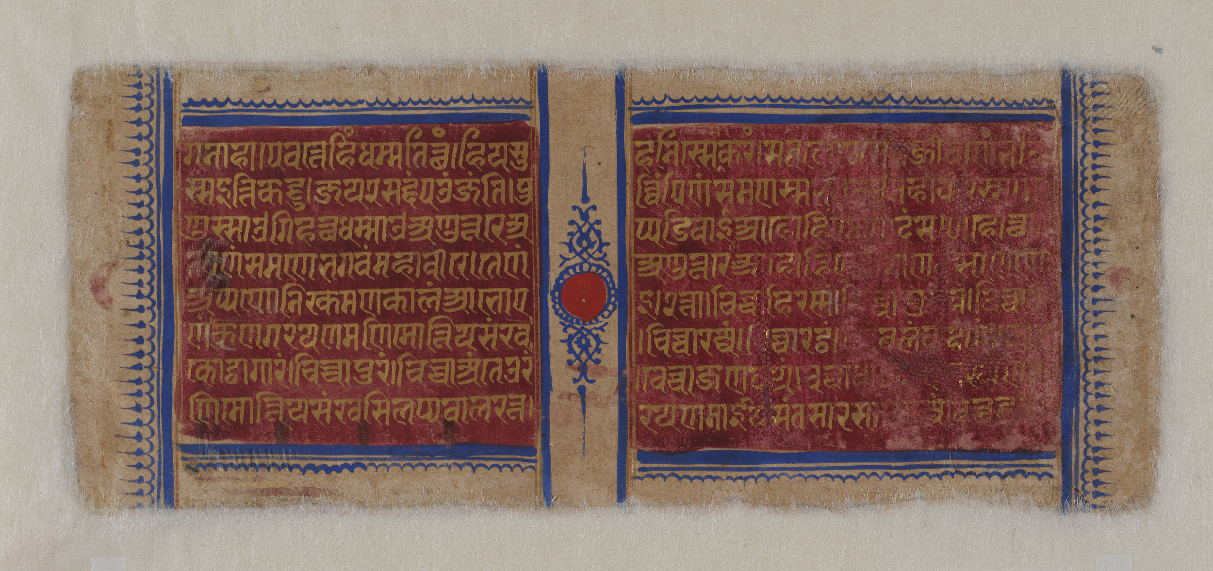
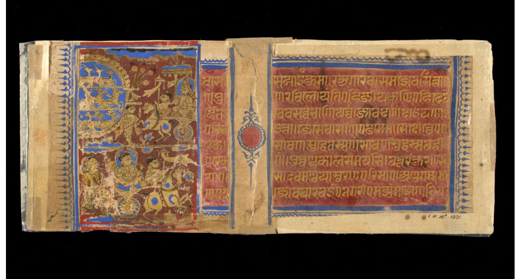
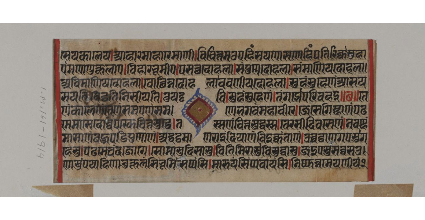
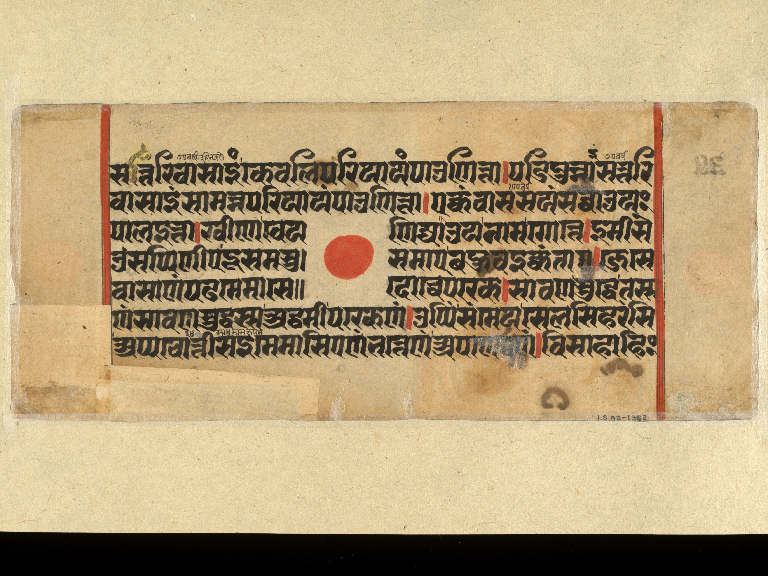
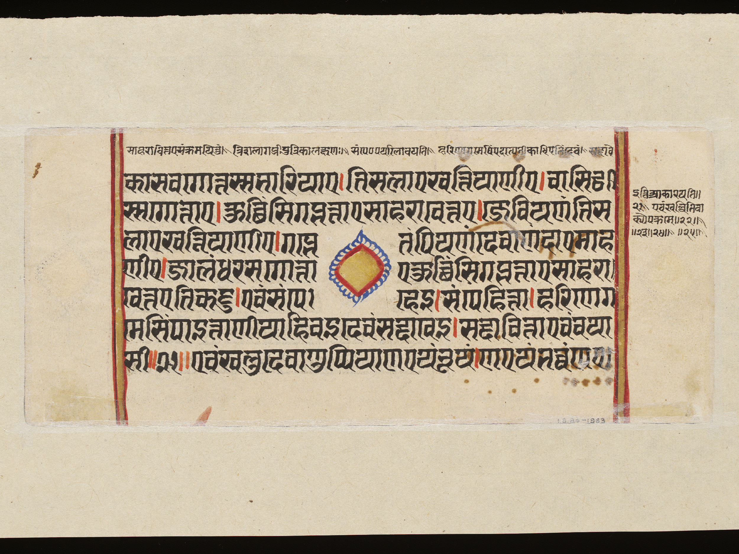
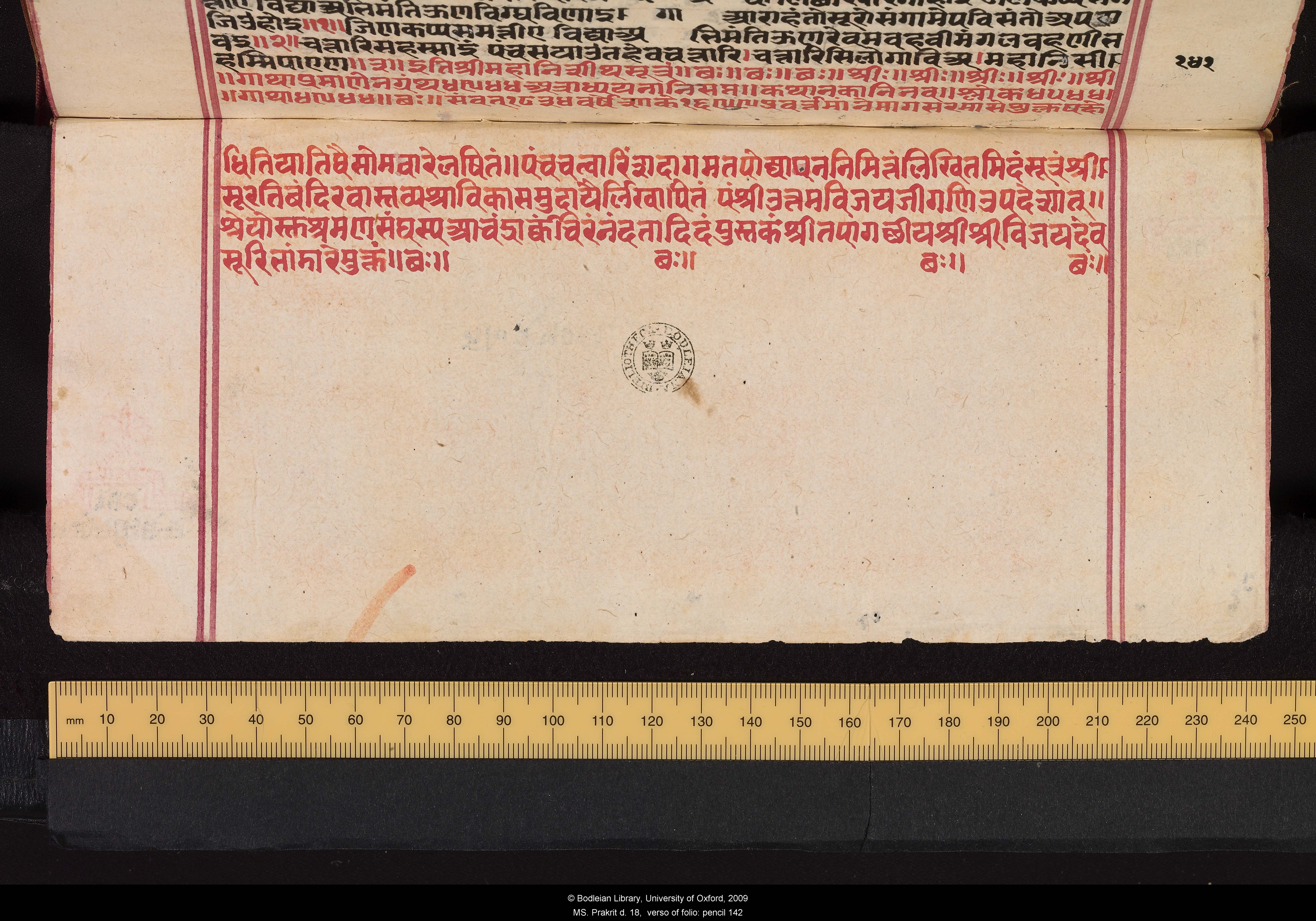
Besides individual captions, such large-scale maps often contain a lot of text inside the main diagram and in the four corners, as here. Here it is written in the local language, which is Rajasthani or a mixture of Gujarati and Hindi. It often includes quotations from earlier treatises in Prakrit or Sanskrit. The text is rather crowded, providing more details about the dimensions and the ordering of the elements in the painting. The most important item of text is on the right-hand side, giving information about who created this painting and when and where. This is valuable because, although there are several such paintings, those that have such facts are rather rare. The text reads: Bṛhatkharataragaccheṃ bha° / jaṃ° / yu / pra / śrī Jinasaubhāgyasūrijī vijayarājye saṃvat 1901 varṣe mitī Poha śudi 11 dine Desaṇoka nagare li / paṃ/ Devarāja Translated, it reads: While the pontiff of the Large Kharatara-gaccha order was the teacher Jinasaubhāgya-sūri, the then prominent teacher of our era, in 1901 of the Vikrama Era [= 1844 CE], on the 11th day of the bright fortnight of the month of Pauṣa, it was written by Pandit Devarāja in the town of Deshnok The Kharatara-gaccha is one of the most important Śvetāmbara monastic orders, dating back to at least the 12th century. It has always been powerful in western India, especially in Rajasthan. Other sources reveal that having paintings of the human world was popular among this order. Pandit Devarāja wrote the textual parts. He could also have been the painter but this is not certain. He was probably not a Jain monk, but rather a learned brahmin who was employed here probably for his expertise in Jain cosmology. The script is written as if the reader is at the edge of the material, looking into its centre. This means the reader must move around the border of the fabric to read it, because staying in one place would mean reading some of the script upside down or at right angles.- Source:
Victoria and Albert Museum
- Shelfmark:
IS 6565
- Author:
unknown
- Date of creation:
1844
- Folio number:
not applicable
- Total number of folios:
not applicable
- Place of creation:
Deshnok, Rajasthan
- Language:
Gujarati / Rajasthani with Sanskrit and Prākrit quotations
- Medium:
painting on cotton or linen
- Size:
153 x 144.5 cms
- Copyright:
V&A Images/Victoria and Albert Museum, London
- Image Copyright:
World of humans
- Source:
Victoria and Albert Museum
- Shelfmark:
IS 6565
- Author:
unknown
- Date of creation:
1844
- Folio number:
not applicable
- Total number of folios:
not applicable
- Place of creation:
Deshnok, Rajasthan
- Language:
Gujarati / Rajasthani with Sanskrit and Prākrit quotations
- Medium:
painting on cotton or linen
- Size:
153 x 144.5 cms
- Copyright:
V&A Images/Victoria and Albert Museum, London
- Image Copyright:

- +
- aAbhavya
- aAbhinandana
- aAbhiṣeka
- aĀcāra
- aĀcārāṅga-sūtra
- aĀcārya
- aAchalbhrata
- aAḍhāī-dvīpa
- aAdharma
- aAdho-loka
- aAdhyayana
- aAdvaita Vedānta
- aĀgama
- aAghātīya
- aAghātīya-karman
- aAgnibhuti
- aAgra
- aĀhāra
- aAhiṃsā
- aAhimsa Day
- aAjita
- aAjīva
- aAkampit
- aĀkāśa
- aAkbar the Great
- aAkṣaya-tṛtīyā
- aAlauddin Khalji
- aAlbert Einstein
- aAllah
- aAlms
- aĀlocanā
- aAloka-ākāśa
- aAmāri
- aAmbikā or Kūṣmāṇḍinī
- aAnagāra
- aAnanta
- aAnarthadaṇḍa
- aAnaśana
- aAnekānta-vāda
- aAṅga
- aAniconism
- aAnojjā
- aAntarāla
- aAntarāya-karma
- aAṇu
- aAṇu-vrata
- aAnukampā
- aAnuprekṣā
- aAnusvāra
- aApabhraṃśa
- aAparigraha
- aAra
- aĀrambha
- aĀrambhaja
- aĀratī
- aArdhamāgadhī Prākrit
- aArhaṃ
- aArhat
- aArśana-āvaraṇīya-karma
- aĀrta-dhyāna
- aĀryikā
- aĀryikā Jñānamati
- aĀśātanā
- aĀścarya
- aAscetic
- aAsceticism
- aAshram
- aAspiration
- aĀsrava
- aAṣṭa-maṅgala
- aAṣṭāpada
- aAstikāya
- aAstrolabe
- aAsura
- aAtheism
- aAticāra
- aAtiśayakṣetra
- aAtithisaṃvibhāgavrata
- aĀtma-vāda
- aĀtman
- aAuṃ
- aAurangzeb
- aAuspicious
- aAusterity
- aAvadhāna
- aAvadhi-jñāna
- aĀvaraṇī-yakarman
- aAvasarpiṇī
- aAvatāra
- aAvidyā
- aAxiom
- aĀyāga-paṭa
- aĀyambil
- aĀyu-karma
- aĀyurveda
- bBabur
- bBāhubali
- bBaladeva
- bBālāvabodha
- bBandha
- bBasadi
- bBazaar
- bBhadrankarvijay
- bBhagavant
- bBhaktāmara-stotra
- bBhakti
- bBhale
- bBharata
- bBhāṣā
- bBhāṣya
- bBhaṭṭāraka
- bBhāva
- bBhāva-pūjā
- bBhāvanā
- bBhavana-vāsin
- bBhavya
- bBhavyatva
- bBhaya
- bBhoga-bhūmi
- bBhogopabhoga
- bBodhi
- bBollywood
- bBrahmā
- bBrahma-deva
- bBrahmacārī
- bBrāhmaṇa
- bBraj Bhāṣā
- bBright fortnight
- bBritish Raj
- bBuddha
- bBuddhi-sagar
- bBuddhism
- bBuddhist
- cCaitya
- cCaityavāsin
- cCakravartin
- cCakreśvarī
- cCāmara
- cCandanā
- cCandragupta
- cCandraprabha
- cCanon
- cCāritra
- cCāritramohanīya-karman
- cCarũrī
- cCaste
- cCaturvidha-saṅgha
- cCaturviṃśati-stava
- cCāturyāma
- cCE
- cCelibacy
- cCha
- cChadmastha
- cChastity
- cCheda-sūtra
- cChristian
- cChristianity
- cClergy
- cCloning
- cColophon
- cCommentary
- cConch
- cConfession
- cCongregation
- cConsecration
- cCosmology
- cCremation
- cCrore
- cCult
- cCūrṇi
- dDādā-guru
- dDalit
- dDāna
- dDaṇḍa
- dDark fortnight
- dDarśana
- dDarśanamohanī-yakarman
- dDaśa-lakṣaṇa-parvan
- dDeity
- dDelhi Sultanate
- dDerāsar
- dDeśāvakāśika-vrata
- dDetachment
- dDevanāgarī
- dDevānandā
- dDevarddhi-gani
- dDevotee
- dDhamal
- dDhanuṣ
- dDhāra
- dDharma
- dDharma-dhyāna
- dDharma-sāgara
- dDharmastikaya
- dDhātakīkhaṇḍa
- dDholak
- dDhyāna
- dDiaspora
- dDig-vrata
- dDigambara
- dDīkṣā
- dDisciple
- dDīvālī
- dDivya-dhvani
- dDNA
- dDoctrine
- dDogma
- dDonor
- dDoṣa
- dDravya
- dDravya-pūjā
- dDrone
- dDuṣamā
- dDuṣamā-duṣamā
- dDuṣamā-suṣamā
- dDveṣa
- dDvīpa
- eEast India Company
- eEightfold Path
- eEkānta-vāda
- eEkendriya
- eElder
- eElders
- eEschatology
- eEtc up to
- fFarmān
- fFast
- fFatehpur Sikri
- fFestival
- fFestschrift
- fFiruz Shah
- fFly-Whisks
- fFolio
- fFour Noble Truths
- gGaccha
- gGaṇa
- gGaṇadhara
- gGanadharavada
- gGaṇeśa
- gGaṇin
- gGarba
- gGarbha
- gGarbha-gṛha
- gGaruḍa
- gGati
- gGene
- gGenomics
- gGhātī-yakarman
- gGhātīya
- gGhaznavid
- gGhiyasuddin Tughlaq
- gGhurid
- gGloss
- gGotra-karma
- gGujarāt
- gGujarati
- gGuṇa
- gGuṇa-sthāna
- gGuṇa-vrata
- gGupti
- gGuru
- gGuruṇī
- hHagiography
- hHajj
- hHaṃsa
- hHaribhadra
- hHariṇaigameṣin
- hHasta
- hHeresy
- hHiṃsā
- hHindi
- hHindu
- hHinduism
- hHīravijaya
- hHoroscope
- hHrīṃ
- hHumayun
- hHymn
- iIconoclasm
- iIconography
- iIdol
- iIndian Independence
- iIndology
- iIndra
- iIndrabhūti Gautama
- iIndriya
- iInitiation
- iIntercession
- iInvocation
- iIQ
- iIslam
- iIslamicate
- iIṣṭadevatā
- iĪśvara
- jJagat
- jJahangir
- jJain
- jJaina Devanāgarī
- jJaina Śaurasenī
- jJaina-dharma
- jJainaśāsana
- jJainness
- jJaisalmer
- jJamāli
- jJambū-dvīpa
- jJames Burgess
- jJanma
- jJanma-kalyāṇa
- jJarā
- jJāti
- jJina
- jJina-āgama
- jJina-bhavana
- jJina-bimba
- jJina-mātā
- jJinacandra-sūri
- jJinadatta
- jJinaprabha
- jJīva
- jJñāna
- jJñāna-āvaraṇīya-karma
- jJñāna-āvarṇiya
- jJñānsundar
- jJyotiṣka
- kKāla
- kKālakācārya-kathā
- kKālidāsa
- kKalpa-sūtra
- kKalpa-vṛkṣa
- kKalyāṇaka
- kKalyanvijay
- kKamaṇḍalu
- kKamaṭha
- kKarma
- kKarma-bhūmi
- kKarma-grantha
- kKarma-prakṛti
- kKarma-vāda
- kKarmon
- kKarnataka
- kKaṣāya
- kKathā
- kKāvya
- kKāya
- kKāyotsarga
- kKeśa-loca
- kKetu
- kKevala-jñāna
- kKevalin
- kKhalji
- kKharatara-gaccha
- kKnowledge
- kKriyā
- kKriyā-vāda
- kKṛṣṇa
- kKṣamā-śramaṇa
- kKṣapakaśreṇi
- kKṣatriya
- kKṣullaka
- kKulakara
- kKundakunda
- kKunthu
- lLabdhi
- lLaity
- lLakh
- lLāñchana
- lLands of Action
- lLaukāntika
- lLavaṇa-samudra
- lLeśyā
- lLiṅga
- lLinguistics
- lLoka
- lLoka-ākāśa
- lLoka-puruṣa
- lLoka-vāda
- lLotus
- lLotus lake
- mMadhya-loka
- mMahā-videha
- mMahā-vrata
- mMahābhārata
- mMahāmastakābhiṣeka
- mMāhārāṣṭra
- mMāhārāṣṭrī Prākrit
- mMahattarā Yākinī
- mMahāvīr Jayantī
- mMahāvīra
- mMakāra
- mMakkhali Gośāla
- mMalli
- mMāna-stambha
- mManaḥ-paryāya-jñāna
- mMaṇḍala
- mMaṇḍapa
- mMandit
- mMaṅgala
- mMantra
- mMantras
- mManuṣya-loka
- mMarāṭhī
- mMārgaṇā
- mMartyr
- mMarudevī
- mMaṭha
- mMati-jñāna
- mMauryaputra
- mMecca
- mMendicant lineage
- mMetarya
- mMiracle
- mMithyādṛṣṭi
- mMohandas Gandhi
- mMohanīya-karma
- mMokṣa
- mMonastic order
- mMonasticism
- mMonk
- mMonotheism
- mMosque
- mMount Meru
- mMount Sammeta
- mMṛgāvatī
- mMughal
- mMuhammad
- mMuhammad bin Tughlaq
- mMuhpattī
- mMūla-sūtra
- mMūlaguṇa
- mMumbaī
- mMuni
- mMunisuvrata
- mMurad Bakhsh
- mMūrti-pūjaka
- mMuslim
- mMysticism
- nNābhi
- nNāga-kal
- nNāgapurīya Tapā-gaccha
- nNāgarī
- nNāma-karma
- nNamaskāra-mantra
- nNami
- nNandīśvara-dvīpa
- nNandivardhana
- nNandyāvarta
- nNāraka
- nNāraki
- nNasalisation
- nNātha
- nNavrātrī
- nNaya-vāda
- nNemi
- nNidāna
- nniggaṃthāṇa vā 2
- nniggaṃtho vā 2
- nNigoda
- nNihnava
- nNikṣepa
- nNirgrantha
- nNirjarā
- nNirvāṇa
- nNiryukti
- nNiṣidhi
- nNitya
- nNiyati
- nNo-kaṣāya
- nNudity
- nNun
- oOcean of milk
- oOmniscience
- oOrdination
- ppa°
- pPadmaprabha
- pPadmāsana
- pPadmāvatī
- pPādukā
- pPalanquin
- pPalette
- pPañca-muṣṭi
- pPāṇḍava
- pPaṇḍit
- pPandit Dalsukh D. Malvania
- pPandit Sukhlalji
- pPāṇipātra
- pPāpa
- pParamātman
- pParameṣṭhin
- pPāraṇā
- pParigraha
- pPariṇāma
- pParīṣaha
- pParokṣa
- pPārśva
- pPārśvanātha
- pParyāya
- pParyuṣaṇ
- pPaṭa
- pPatan
- pPātra
- pPenance
- pPersian
- pPhala
- pPhilology
- pPicchikā
- pPilgrimage
- pPīr
- pPolymath
- pPoṣadha
- pPossession
- pPothī
- pPrabhas
- pPradakṣiṇā
- pPradeśa
- pPrākāra
- pPrakīrṇaka-sūtra
- pPrākrit
- pPramāda
- pPramukhā
- pPrati-vāsudeva
- pPratikramaṇa
- pPratimā
- pPratiṣṭhā
- pPratyākhyāna
- pPratyakṣa
- pPravacana
- pPrāyaścitta
- pPrayer
- pPre-modern
- pPreach
- pPredestination
- pProtestant
- pProvenance
- pPudgala
- pPūjā
- pPujārī
- pPukharavara-dvīpa
- pPuṇya
- pPūrva
- pPuṣkara-dvīpa
- pPuṣpadanta
- pPyre
- qQur’an
- rRāga
- rRāhu
- rRainy season
- rRajasthan
- rRajasthani
- rRājimatī
- rRajoharaṇa
- rRajput
- rRāma
- rRāmāyaṇa
- rRangoli
- rRās-garbā
- rRasa
- rRathanemi
- rRatna-traya
- rRātri-bhojana
- rRaudra-dhyāna
- rRecto
- rRelic
- rRenunciation
- rRetroflex
- rRevatī
- %Ṛg-veda
- rRite
- rRosary
- %Ṛṣabha
- %Ṛṣabhanātha
- rRupee
- sSaciyā Mātā
- sSādhu
- sSādhvī
- sSāgāra
- sSaint
- sŚaivaism
- sŚaka-saṃvat
- sSallekhanā
- sŚalya
- sSamacatuṣṭha
- sSamādhimaraṇa
- sSamaṇi
- sSāmarambha
- sSamavasaraṇa
- sSāmāyika
- sSaṃbhava
- sSamiti
- sSaṃjñā
- sSaṃkalpaja
- sSaṃsāra
- sSamudghāta
- sSaṃvara
- sSaṃvega
- sSamyak-cāritra
- sSamyak-darśana
- sSamyak-jñāna
- sSamyaktva
- sSaṃyama
- sSanctuary
- sSandalwood
- sSaṇgha
- sSanskrit
- sSant
- sŚānti
- sSapta-bhaṅgi-naya
- sSārambha
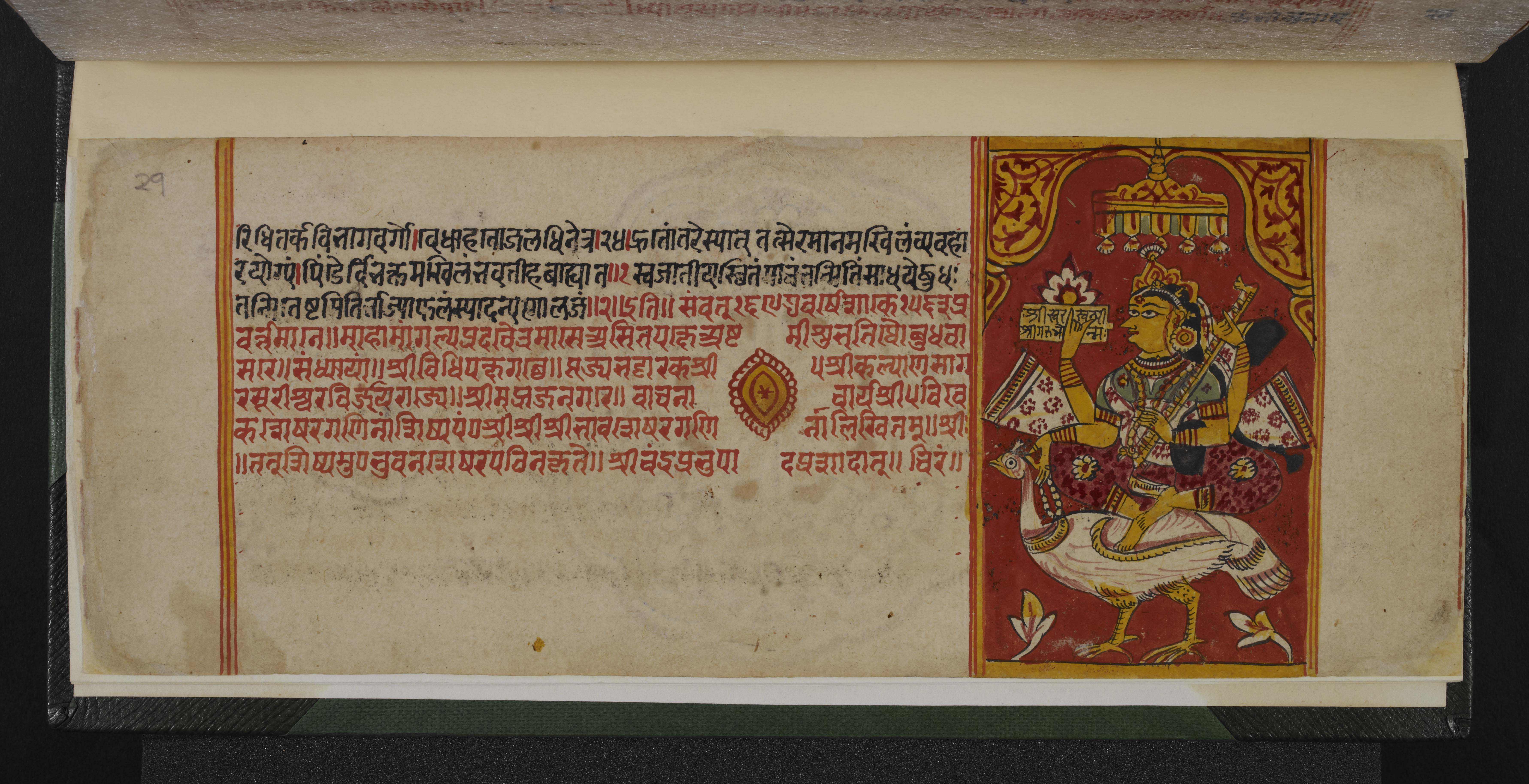
- sSarasvatī
- sSarvajña
- sSāsan-devi
- sŚāsana-devatā
- sŚāstra
- %Ṣaṭ-jīvanikāya
- sSatī
- sSatīmātā
- sSatya
- sSchism
- sScribe
- sScripture
- sSect
- sSecularism
- sŚenāī
- sSermon
- sŚeṣavatī
- sSevā
- sSeven fields of donation
- sShah Jahan
- sShantidas Jhaveri
- sShrine
- sSiddha
- sSiddha-śilā
- sSiddhacakra or Navadevatā
- sSiddhānta
- sSiddhārtha
- sSiddhi
- sSikh
- sSikhism
- sŚikṣā-vrata
- sŚīla
- sSin
- sSindh
- sŚītala
- sŚiva
- sSkandha
- sSomanatha
- sŚraddhā
- sŚramaṇa
- sŚrāvaka
- sŚrāvakācāra
- sŚrāvikā
- sŚreyāṃsa
- sŚrī
- sŚrīvatsa
- sŚruta-jñāna
- sŚruta-pañcamī
- sSthānaka-vāsin
- sSthāpanācārya
- sSthāvara
- sSthavira
- sSthiti
- sStrīmukti
- sStūpa
- sSubcontinent
- sSudarshana
- sŚuddhi
- sSudharma
- sŚūdra
- sSufism
- sSukha
- sŚukla-dhyāna
- sSulasā
- sSultan
- sSumati
- sSundarśrī
- sSupārśva
- sSūri
- sSuṣamā
- sSuṣamā-duṣamā
- sSuṣamā-suṣamā
- sSūtra
- sSuyam me ausam! Tenam bhagavaya evamakkhayam
- sSvādhyāya
- sSvāhā
- sSvastika
- sŚvetāmbara
- sŚvetāmbara Terāpanthin
- sŚvetāmbaras
- sSwan
- sSyād-vāda
- tTabla
- tTantra
- tTapā-gaccha
- tTapas
- tTāraṇ Svāmī Panth
- tTattva
- tTattvārtha-sūtra
- tTemple
- tTemple-city
- tThe Enlightenment
- tTheology
- tThree worlds
- %Ṭīkā
- tTilaka
- tTīrtha
- tTīrthaṃkaranāma-karman
- tTīrthankara
- tTransliteration
- tTrasa
- tTrasa-nāḍī
- tTriśalā
- tTriṣaṣṭi-śalākā-puruṣa-caritra
- tTti bemi
- tTughlaq
- tTunk
- uUdumbara
- uUniversal History
- uUpādhyāya
- uUpāṅga
- uUpaniṣads
- uUpāsaka
- uUpasarga
- uUpāśraya
- uŪrdhva-loka
- uUtsarpiṇī
- uUttarādhyayana-sūtra
- vVāhana
- vVaimānika
- vVairāgya
- vVaiṣṇava
- vVaiśramaṇa
- vVaiśya
- vValabhī
- vVanaspatikāya
- vVandana
- vVaṇik
- vVarṇa
- vVāsudeva
- vVāsupūjya
- vVayubhūti
- vVeda
- vVedanīya-karma
- vVegetarianism
- vVehicle
- vVernacular
- vVerso
- vVidyā
- vVidyā-devī
- vVihāra
- vVijñapti-patra
- vVikrama-saṃvat
- vVikṛti
- vVimala
- vVinaya
- vVipāka
- vVirji Vora
- vVirodhaja
- vVīrya
- vVisarga
- vViṣṇu
- vVītarāga
- vVizier
- vVotive
- vVow
- vVrata
- vVS
- vVyakta
- vVyantara
- vVyasana
- yYakṣa
- yYakṣī
- yYantra
- yYaśoda
- yYaśovijaya
- yYati
- yYātrā
- yYoga
- yYoginī
- yYojana
Description
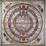
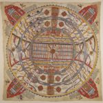
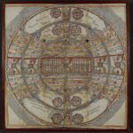
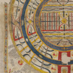
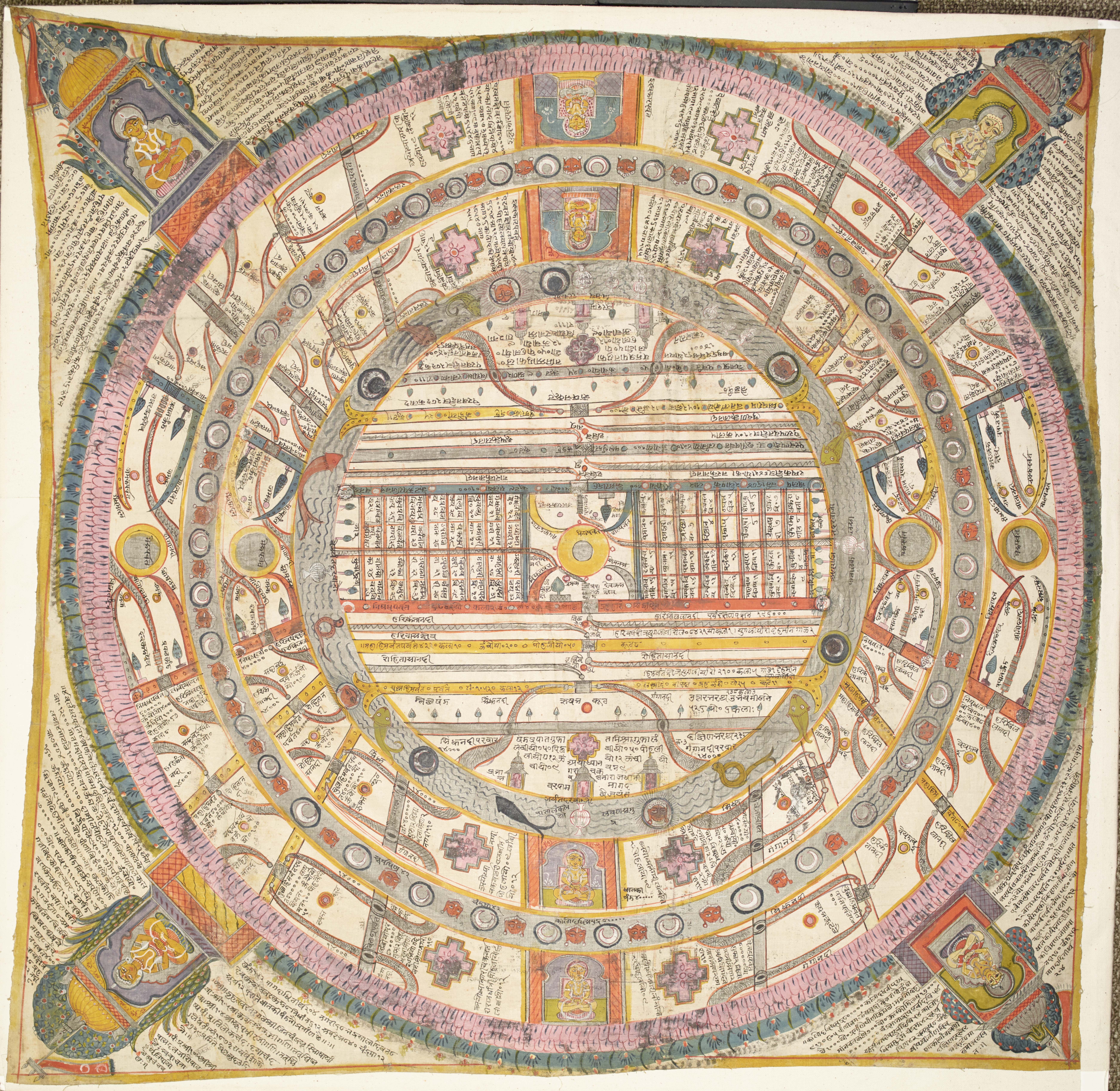
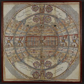
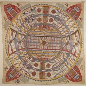
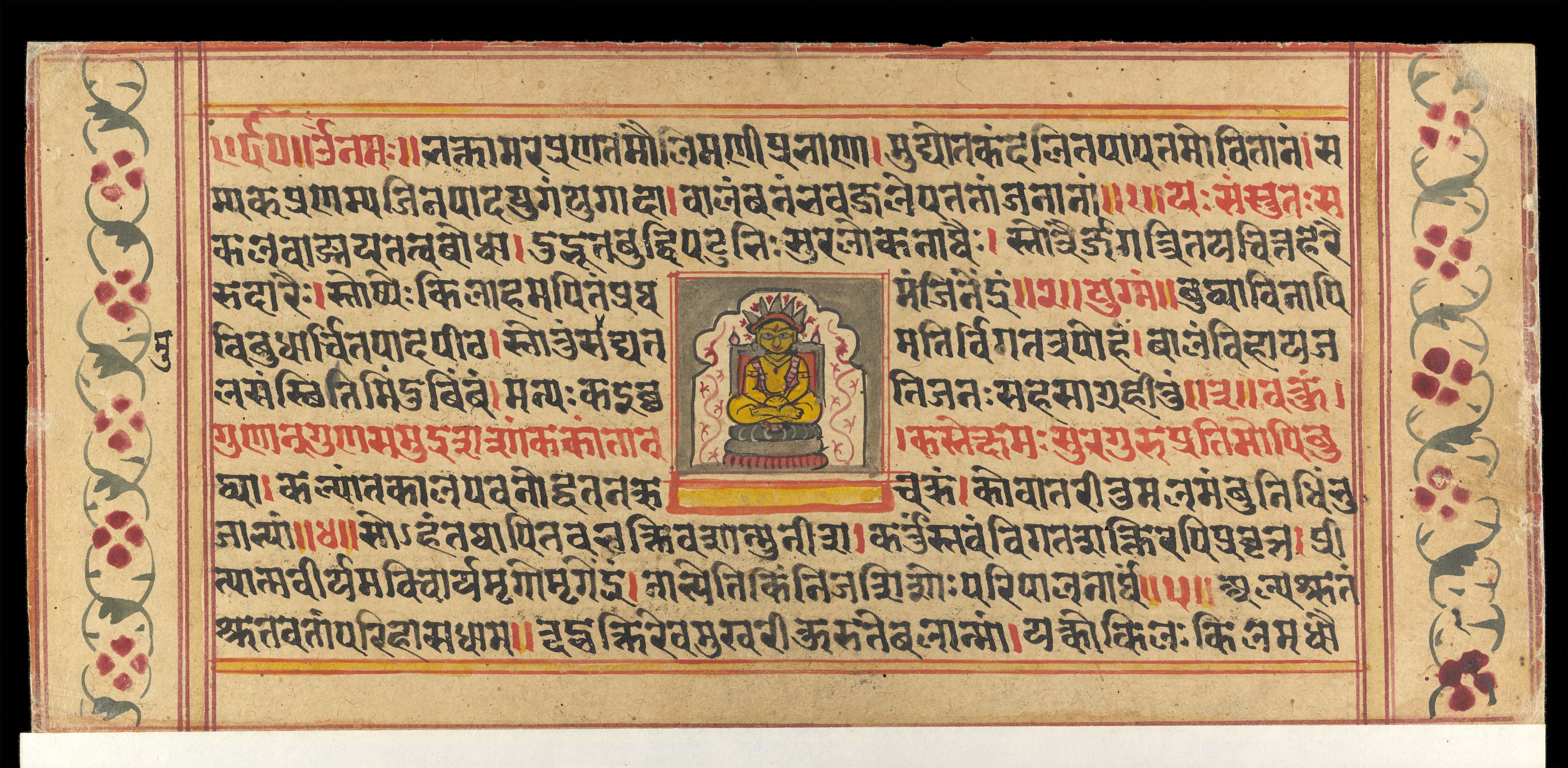
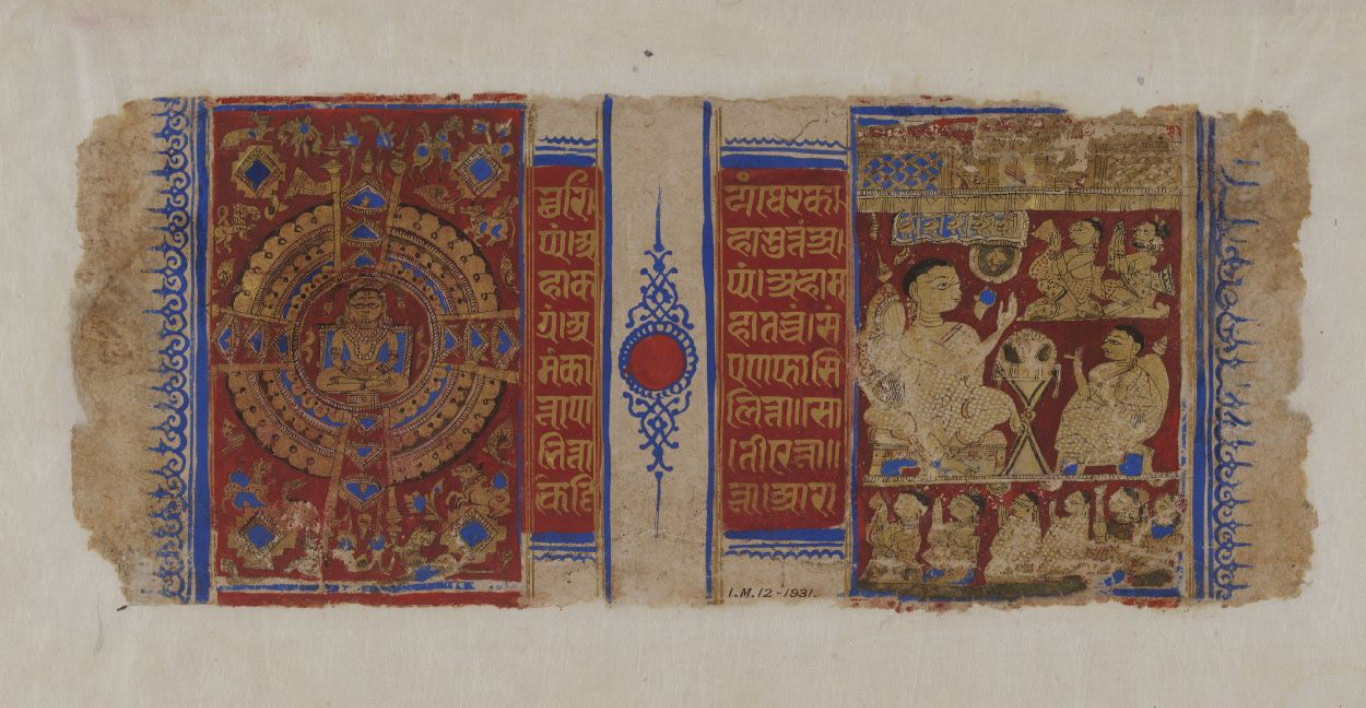
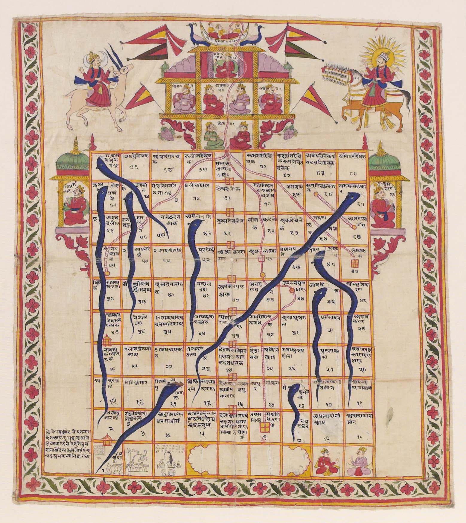
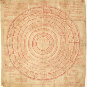
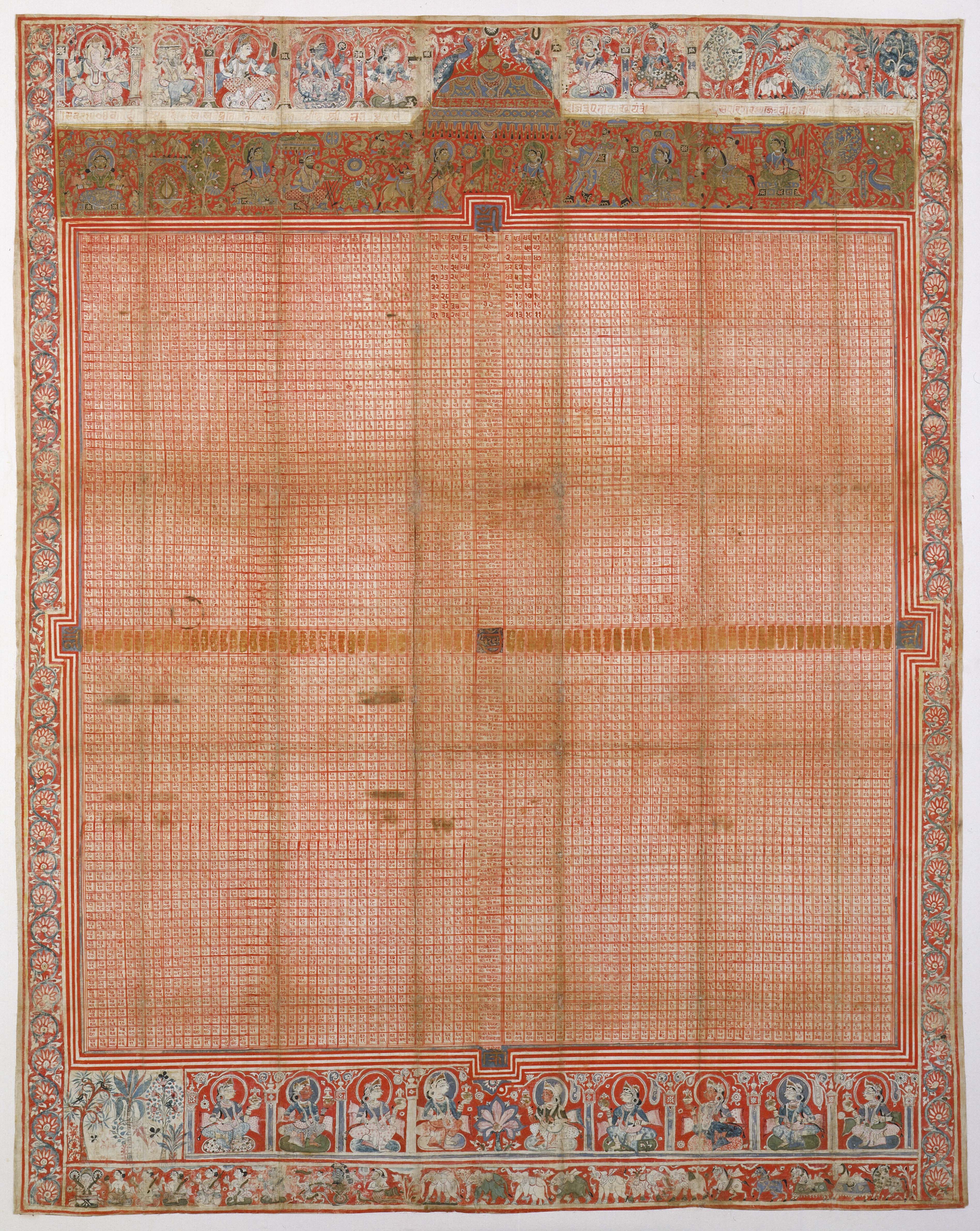
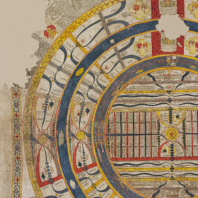
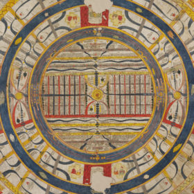
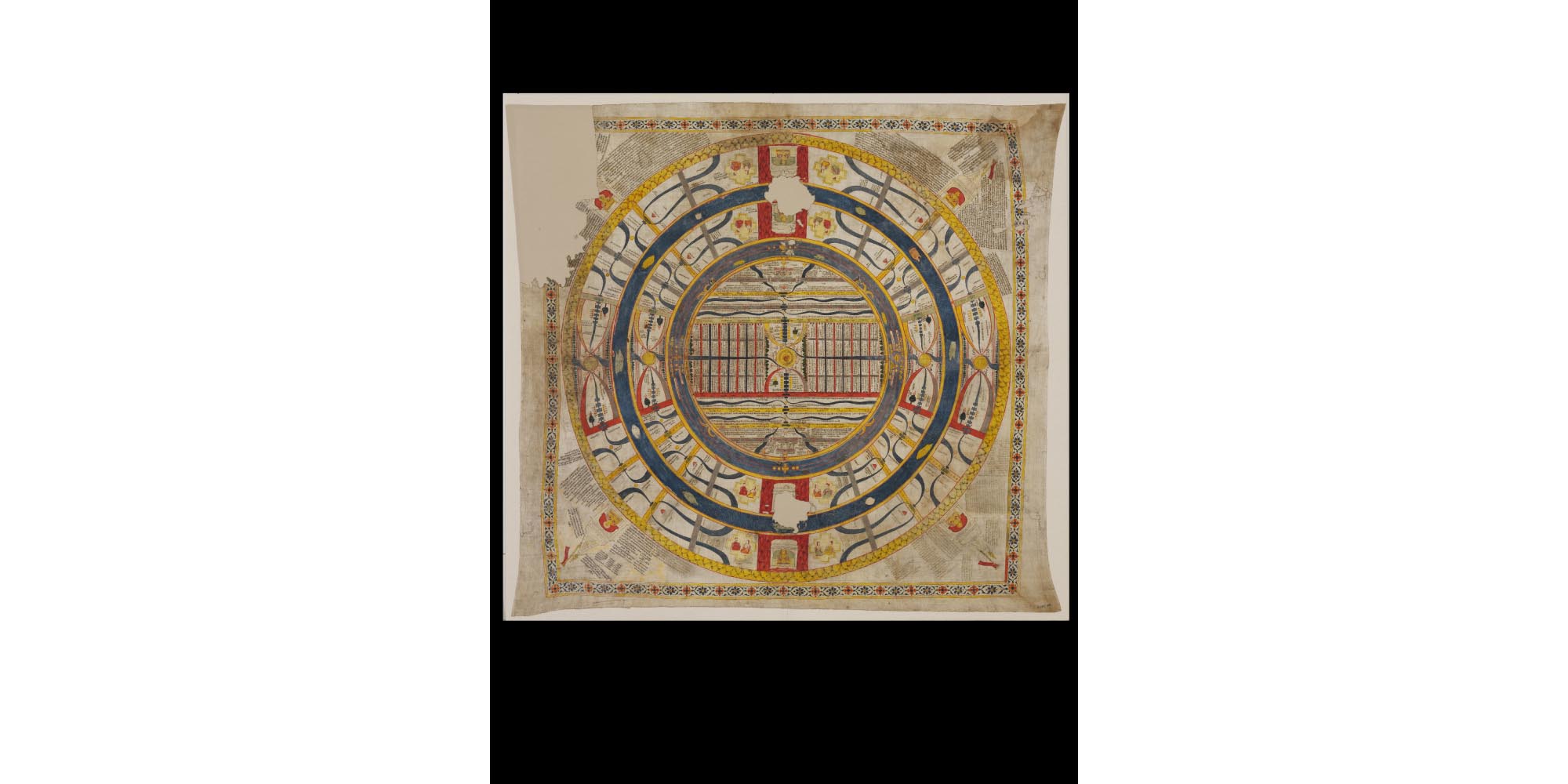
This is the traditional representation of the world of human beings in Jain cosmology. It is made up of alternate concentric circles representing continents, mountains and oceans. Since symmetry and repetition are two of the major organising principles of the Jain world, geographical features – including names – are often the same in different regions.
The main part of the diagram consists of concentric rings in alternating grey, blue and yellow around a central circle. In the centre of the diagram is Mount Meru, shown as a yellow disc, the heart of the Two and A Half Continents.
Mount Meru is in the middle of the circular continent of Jambū-dvīpa, shown with a pale background.
Around Jambū-dvīpa is the ocean of Lavaṇa-samudra – ‘Salt Ocean’ – shown as a blue-grey circle.
Around Lavaṇa-samudra is the continent of Dhātakīkhaṇḍa.
Around that is the ocean of Kālodadhi or ‘Black Water Ocean’, again a blue cicle.
Around Kālodadhi is another circle of land. This is half of the Puṣkara continent.
Together, these continents and oceans form Aḍhāī-dvīpa, which is a Hindi term meaning ‘Two and A Half Continents’. Thus the painting is a map of the cosmological concept of the Two and A Half Continents. The Two and a Half Continents is in the centre of the Middle World – madhya-loka. There are three worlds in the Jain conception of the universe. The Two and A Half Continents is the only part of the universe where human beings can be born so it is also known as ‘the World of Humans’ – manuṣya-loka.
At the perimeter of Puṣkara-dvīpa is a slim crenellated yellow band. This is the outer mountain range beyond which no human beings live. It is known as Mānuṣottara.
Large-scale maps such as this one became popular from the 15th century onwards among Śvetāmbara circles in western India, especially Rajasthan. This is precisely the region where this painting comes from (see below).
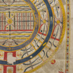
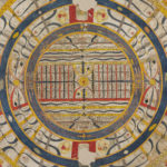
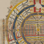
Mount Meru
The three concentric circles in Mount Meru represent its three terraces. On the top is the pinnacle with the customary temple to the Jinas.
On each side of each Mount Meru are two semicircles, one yellow, one red and grey. They are the boundaries of two regions. The northern one is called Uttara-kuru, the southern one Deva-kuru. Each region has a specific tree.
| Colour in this painting | Location | Region | Name of the tree |
|---|---|---|---|
| Yellow | North | Uttara-kuru | Jambū tree |
| Red and grey | South | Deva-kuru | Śālmalī tree |
Five small dark rectangles in each of the two regions represent lakes. The River Sītā flows through Deva-kuru while the River Sītodā runs through Uttara-kuru. These regions are the Lands of Enjoyment – bhoga-bhūmi – where people get all they need from ‘wishing trees’ – kalpa-vṛikṣa – and do not need to make any effort. Couples made up of twin boys and girls live in the Lands of Enjoyment. The regions of Uttara-kuru and Deva-kuru are also shown in the western and eastern halves of the two other continents, mirror images of Jambū-dvīpa.
Jambū-dvīpa
Across the centre of Jambū is a large rectangular strip marked out by a green line in the north and a red one in the south. These are ranges of mountains, which are easily recognisable in most paintings because of their standard colours. The Nīla mountain range is in the north and is marked in green while the Niṣadha mountain range in the south is outlined in red. They mark the boundaries of the Mahā-videha, which has Mount Meru at its centre. The Mahā-videha is a land of wonders, where Universal Monarchs go and where Jinas preach.
The Mahā-videha is divided into 32 provinces, distributed as eight groups of four, equally in the north-east, south-east, north-west and south-west. They are always shown as small rectangles, like here. On this painting the names of these provinces and their capitals are given.
The green trees on the borders of the Mahā-videha stand for the forests in this region.
Lavaṇa-samudra
The first ocean, starting from the centre, is the thick blue-grey ring around Jambū. Called Lavaṇa-samudra, it has one pot in each of the four directions. These are the ‘great receptacles’ – pātāla-kalaśas – that cause the tides.
Fish and other aquatic animals live here, often depicted as realistic or semi-fantastic creatures.
There are two horizontal yellow lines ending with double hook shapes shown in the north and south of this ocean. These are two mountain chains that end with double pairs of ‘tusks’ jutting out into Lavaṇa-samudra. These tusks carry the 56 islands known as Antara-dvīpas. The islands are divided into seven groups of eight, shown here as dots.
Dhātakīkhaṇḍa
From north to south there are parallel red vertical lines dividing the Dhātakīkhaṇḍa and Puṣkara-dvīpa continents into two halves, eastern and western. Each half has temples dedicated to the Jinas. The four segments of these parallel lines on land represent a mountain range known as Iṣvākāra or ‘Arrow-like’ because it is perfectly straight.
On the right and left sides of the red vertical lines, the yellow lozenges are capital cities with palaces. The royal couples who live in them are shown on the map in yellow structures representing the palaces.
There are two yellow discs on the left and right and two semicircles on each side of these discs. These are replicas of Mount Meru and the two Lands of Enjoyment, Uttara-kuru and Deva-kuru.
The numerous snake-like dark blue shapes are rivers flowing in the continents. The small black rectangles in many places are the lakes where these rivers rise.
Kālodadhi
This ocean is the blue ring separating the continents of Dhātakīkhaṇḍa and Puṣkara-dvīpa. It often contains fantastic creatures.
Half Puṣkara-dvīpa
The Puṣkara continent is a replica of Dhātakīkhaṇḍa. However, the outer border of Puṣkara-dvīpa is shown by a slim yellow ring. This is the outer mountain range called Mānuṣottara. Even though half of the continent lies on the far side, no human beings can live outside this mountain range.
Other visual elements
The painting has captions identifying the elements of the world and also paragraphs giving details of dimensions and so on.
As is usual, a Jain temple has been set at each of the four corners of the painting. One is missing because the artefact is damaged.
There is an image of a Jina in the centre, which is meant to be worshipped. This is a standard representation to suggest that Jain teaching is everywhere.
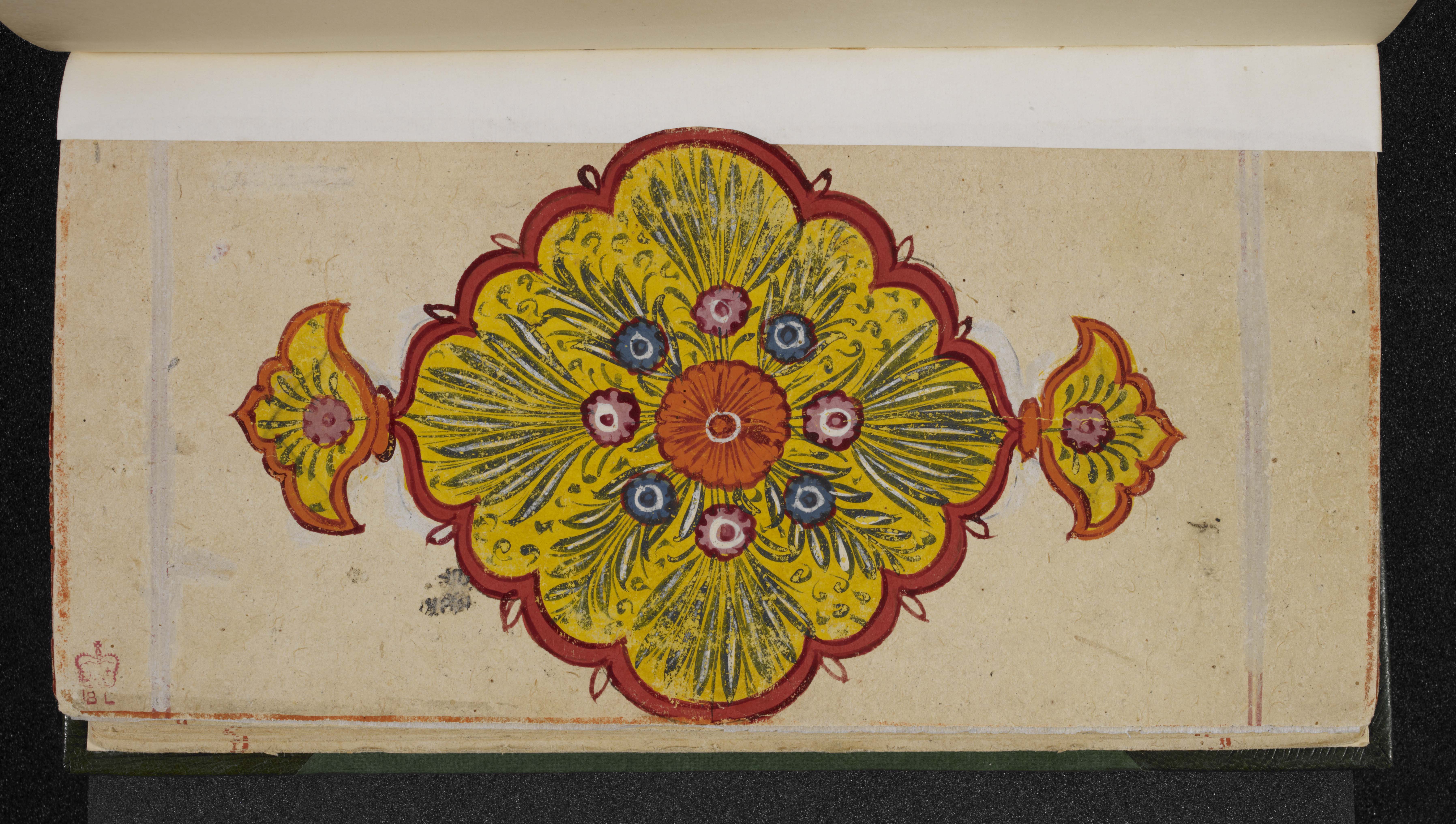
The floral border around the edge of the painting is a fine ornamentation.
Text
Besides individual captions, such large-scale maps often contain a lot of text inside the main diagram and in the four corners, as here. Here it is written in the local language, which is Rajasthani or a mixture of Gujarati and Hindi. It often includes quotations from earlier treatises in Prakrit or Sanskrit. The text is rather crowded, providing more details about the dimensions and the ordering of the elements in the painting.
The most important item of text is on the right-hand side, giving information about who created this painting and when and where. This is valuable because, although there are several such paintings, those that have such facts are rather rare.
The text reads:
Bṛhatkharataragaccheṃ bha° / jaṃ° / yu / pra / śrī Jinasaubhāgyasūrijī vijayarājye saṃvat 1901 varṣe mitī Poha śudi 11 dine Desaṇoka nagare li / paṃ/ Devarāja
Translated, it reads:
While the pontiff of the Large Kharatara-gaccha order was the teacher Jinasaubhāgya-sūri, the then prominent teacher of our era, in 1901 of the Vikrama Era [= 1844 CE], on the 11th day of the bright fortnight of the month of Pauṣa, it was written by Pandit Devarāja in the town of Deshnok
The Kharatara-gaccha is one of the most important Śvetāmbara monastic orders, dating back to at least the 12th century. It has always been powerful in western India, especially in Rajasthan. Other sources reveal that having paintings of the human world was popular among this order.
Pandit Devarāja wrote the textual parts. He could also have been the painter but this is not certain. He was probably not a Jain monk, but rather a learned brahmin who was employed here probably for his expertise in Jain cosmology.
The script is written as if the reader is at the edge of the material, looking into its centre. This means the reader must move around the border of the fabric to read it, because staying in one place would mean reading some of the script upside down or at right angles.